Нет, это только в патче. В ИТ отображается нормально, в классике надо в патче ковырять.если я не ошибаюсь, то нпц нужно добавить кол-во хп и в нпц групп тоже
You are using an out of date browser. It may not display this or other websites correctly.
You should upgrade or use an alternative browser.
You should upgrade or use an alternative browser.
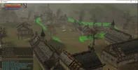
Нужно расчертить локу!
- Thread starter xapu3ma
- Start date
This will come in the new update?
Сделал панель для полного менеджмента зон
В ИТ есть единственное НО! Если сделать ТП в другой регион, надо релогать клиент иначе не отображаться разметка визуальная. Почему - без понятия, ни очистка старых координат, ничего не повторный телепорт и тд.
already on repoThis will come in the new update?
Patch=HPShowwhere changes?
flag=noShowHP?
still need to kill to capture.....
so a mage will capture from 900 distance
Still Need to kill - yes, min damage distance at Configs. You can check it
Code:
# Minimum distance to damage a flag
# If the distance is greater, there'll be 0 damage.
CTF_FlagMinAttackDistance = 300

well, is it require so much changes to make it-> reach some distance near it to take flag?Patch=HPShow
Still Need to kill - yes, min damage distance at Configs. You can check it
Code:# Minimum distance to damage a flag # If the distance is greater, there'll be 0 damage. CTF_FlagMinAttackDistance = 300
The previous idea of capturing a player was flawed. It required multiple conditions to be met. This was unlike the simpler flag-capturing approach.well, is it require so much changes to make it-> reach some distance near it to take flag?
Anyway, you can set HP for FlagNpc like 1. And on one hit it will be captured
для мп тоже уже есть обнова?
Сделал панель для полного менеджмента зон
В ИТ есть единственное НО! Если сделать ТП в другой регион, надо релогать клиент иначе не отображаться разметка визуальная. Почему - без понятия, ни очистка старых координат, ничего не повторный телепорт и тд.
утром сяду и сведу все обновыдля мп тоже уже есть обнова?
Залил все обновыдля мп тоже уже есть обнова?
like at data/zones min max Z, you do not need to do nothingWhen the green lines are UP I need to increase the HEIGHT like now is -3420 I need to make it -7000? (to go down to the ground?)
PTS Zone i don't know why very high. Auto-builder makes +100 - 100 Z = 200 zDiff.
if you see that you need a high zone, increase it in the finished XML itself.
For example, character Z -3000. You need to make zMin -3100 zMax -2900
Ok so correct me if Im wrong. The green lines are only just for visual guide. No matter how high/low are they.like at data/zones min max Z, you do not need to do nothing
PTS Zone i don't know why very high. Auto-builder makes +100 - 100 Z = 200 zDiff.
if you see that you need a high zone, increase it in the finished XML itself.
For example, character Z -3000. You need to make zMin -3100 zMax -2900
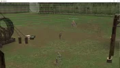
For example I am trying to make Ruins of Angory with limits like level and items. I tried to make it on sections but still the zone is like broken. It's always says you enter a zone/ you exit a zone like the coordinates are missing. So I think I need to make it in sections where the ground is even. But in some cases like the attached image if the player step on the top where the green line is not visible it don't get the restriction. I will leave the coordinates if someone want to test ... I think it's very difficult to build a zone where the terrain is not even.
HTML:
<zone name="[zone_angory]" type="fun">
     <set name="enabled" val="true" />
    <set name="playerMinLevel" val="78" />
    <set name="playerMaxLevel" val="84" />
    <set name="playerLevelLimitBackLoc" val="43627 189220 -3512" />
    <set name="zoneAllowedItemIds" val="6577;6578;16110;16111;" />
    <polygon>
        <coords loc="-53317 108604 -3828 -3700" />
        <coords loc="-53192 108328 -3820 -3700" />
        <coords loc="-53061 107465 -3820 -3700" />
        <coords loc="-53271 106840 -3820 -3700" />
        <coords loc="-55105 106384 -3820 -3700" />
        <coords loc="-55473 107159 -3804 -3700" />
        <coords loc="-55700 107439 -3820 -3700" />
        <coords loc="-56387 107762 -3796 -3700" />
        <coords loc="-55661 108643 -3828 -3700" />
        <coords loc="-54811 109525 -3788 -3700" />
    </polygon>
</zone>

    <zone name="[zone_angory2]" type="fun">
    <set name="playerMinLevel" val="78" />
    <set name="playerMaxLevel" val="84" />
    <set name="playerLevelLimitBackLoc" val="43627 189220 -3512" />
    <set name="zoneAllowedItemIds" val="6577;6578;16110;" />

    <polygon>
        <coords loc="-53447 108761 -3812 -3612" />
        <coords loc="-53368 108807 -3812 -3612" />
        <coords loc="-52991 109019 -3828 -3628" />
        <coords loc="-52148 109624 -3812 -3612" />
        <coords loc="-51384 110218 -3788 -3588" />
        <coords loc="-51261 110274 -3764 -3564" />
        <coords loc="-50811 110651 -3684 -3484" />
        <coords loc="-50384 110323 -3676 -3476" />
        <coords loc="-50808 109849 -3812 -3612" />
        <coords loc="-49884 108710 -3828 -3628" />
        <coords loc="-50317 107868 -3812 -3612" />
        <coords loc="-51336 108244 -3828 -3628" />
        <coords loc="-53079 107574 -3820 -3620" />
    </polygon>
</zone>